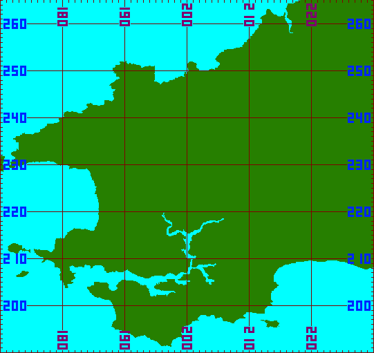
List of Pembrokeshire Toilets
| Toilet | OS Grid Ref Lat, Lon | Map Ref. Across Up |
|---|---|---|
| Abercastle | 185388 233516 51.959, -5.125 | 185 233 |
| Abereiddi | 179825 231288 51.936, -5.204 | 179 231 |
| Amroth East | 217133 207281 51.734, -4.650 | 217 207 |
| Amroth West | 216221 207048 51.732, -4.663 | 216 207 |
| West Angle | 185312 203547 51.690, -5.108 | 185 203 |
| Bosherston | 196504 194825 51.615, -4.941 | 196 194 |
| Broad Haven North | 186291 213948 51.783, -5.100 | 186 213 |
| Broad Haven South | 186131 213557 51.780, -5.102 | 186 213 |
| Burton Jolly Sailor | 198171 205095 51.708, -4.923 | 198 205 |
| Carew Castle | 204136 203796 51.699, -4.836 | 204 203 |
| Cilgerran Picnic Area | 219628 242963 52.056, -4.632 | 219 242 |
| Cresswell Quay | 205019 206674 51.725, -4.825 | 205 206 |
| Cwm Yr Eglwys | 201365 240047 52.023, -4.897 | 201 240 |
| Dale | 180724 205668 51.707, -5.175 | 180 205 |
| Velindre Varhog | 210532 238860 52.016, -4.762 | 210 238 |
| Lower Town | 196290 237306 51.997, -4.969 | 196 237 |
| Fishguard Parc y Shwt | 195730 236908 51.993, -4.977 | 195 236 |
| Fishguard West Street | 195523 237240 51.996, -4.980 | 195 237 |
| Freshwater East | 201635 197609 51.642, -4.868 | 201 197 |
| Freshwater West | 190723 198683 51.648, -5.026 | 190 198 |
| Goodwick Parrog | 194649 238025 52.003, -4.993 | 194 238 |
| Haverfordwest Castle Lake | 195149 215652 51.802, -4.973 | 195 215 |
| Hazelbeach | 194748 204766 51.704, -4.972 | 194 204 |
| 195479 215838 51.804, -4.968 | 195 215 | |
| Johnston Pope Hill | 193674 212129 51.770, -4.992 | 193 212 |
| Kilgetty Car Park | 212325 207215 51.732, -4.719 | 212 207 |
| Letterston | 194496 229690 51.928, -4.990 | 194 229 |
| Little Haven | 185755 212899 51.774, -5.107 | 185 212 |
| Maenclochog | 208310 227315 51.911, -4.788 | 208 227 |
| Manorbier | 206342 197706 51.645, -4.800 | 206 197 |
| Marloes | 179358 208393 51.731, -5.197 | 179 208 |
| Martins Haven | 177394 208969 51.735, -5.225 | 177 208 |
| Milford Haven Market Square | 190285 205961 51.713, -5.037 | 190 205 |
| Milford Haven Rath | 190989 205640 51.710, -5.027 | 190 205 |
| Moylegrove | 211744 244654 52.068, -4.748 | 211 244 |
| Narberth Town Moor | 210812 214741 51.799, -4.745 | 210 214 |
| Nevern | 208324 239767 52.023, -4.795 | 208 239 |
| Newgale Duke of Edinburgh | 184852 222466 51.859, -5.126 | 184 222 |
| Newgale Central | 184852 222466 51.859, -5.126 | 184 222 |
| Newgale Pebbles | 185506 222022 51.855, -5.116 | 185 222 |
| Newport Long Street | 205729 239254 52.018, -4.833 | 205 239 |
| Newport Parrog | 205207 239582 52.020, -4.840 | 205 239 |
| Newport Traeth Mawr | 205780 240395 52.028, -4.832 | 205 240 |
| Neyland Marina | 196640 205125 51.708, -4.945 | 196 205 |
| Nolton Haven | 186059 218696 51.826, -5.106 | 186 218 |
| Pembroke Blackhorse Walk | 198917 201312 51.675, -4.910 | 198 201 |
| Pembroke The Commons | 198320 201412 51.675, -4.918 | 198 201 |
| Pembroke Town Quay | 198336 201566 51.677, -4.918 | 198 201 |
| Pembroke Dock Library | 196972 203687 51.695, -4.939 | 196 203 |
| Penally | 211799 199068 51.659, -4.722 | 211 199 |
| Penblewin | 212847 216694 51.817, -4.717 | 212 216 |
| Poppit Sands | 215204 248487 52.104, -4.700 | 215 248 |
| Porthclais | 174067 224285 51.871, -5.283 | 174 224 |
| Porthgain | 181545 232506 51.948, -5.180 | 181 232 |
| Pwllgwaelod | 200944 239586 52.019, -4.902 | 200 239 |
| Saint Brides | 180247 211025 51.755, -5.185 | 180 211 |
| Saint Davids Bryn Road | 175367 225269 51.881, -5.265 | 175 225 |
| Saint Davids Quickwell | 175335 225554 51.883, -5.266 | 175 225 |
| Saint Davids The Grove | 175672 225216 51.880, -5.261 | 175 225 |
| Saint Dogmaels High Street | 216422 245993 52.082, -4.681 | 216 245 |
| Saint Ishmaels | 183763 207105 51.721, -5.132 | 183 207 |
| Saundersfoot Regency Hall | 213554 204799 51.711, -4.700 | 213 204 |
| Solva Lower | 180615 224339 51.874, -5.188 | 180 224 |
| Tenby Butts Field | 213253 201062 51.677, -4.702 | 213 201 |
| Tenby Castle Beach | 213653 200457 51.672, -4.696 | 213 200 |
| Tenby Multi-Storey | 213229 200450 51.672, -4.702 | 213 200 |
| Tenby North Beach | 213241 200825 51.675, -4.703 | 213 200 |
| Tenby Salterns | 212878 200488 51.672, -4.708 | 212 200 |
| Tenby South Beach | 213132 200107 51.669, -4.704 | 213 200 |
| Tenby U. Frog Street | 213315 200494 51.672, -4.701 | 213 200 |
| Whitesands | 173517 227399 51.899, -5.293 | 173 227 |
| Wisemans Bridge | 214515 206118 51.723, -4.687 | 214 206 |
- Most of these lists use data derived from OS Open Names
- Contains Ordnance Survey data © Crown copyright and database right 2023.
- Contains National Statistics data © Crown copyright and database right 2023.
- There are some Pembrokeshire locations which share the same name
- Examples include two villages, both called Sardis
- I have removed any accents and apostrophies from location names.
- Some browsers do not display certain accented charaters correctly.
- The presence of apostrophies in place-names appears to change with time, source and town
DigitalDan.co.uk
