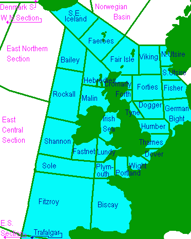
Map of the UK showing the Shipping Forecast areas used by the Met Office during the Shipping Weather Forecast.
Viking, North Utsire, South Utsire, Forties, Cromarty, Forth, Tyne, Dogger, Fisher, German Bight, Humber, Thames, Dover, Wight, Portland, Plymouth, Biscay, Trafalgar, FitzRoy, Sole, Lundy, Fastnet, Irish Sea, Shannon, Rockall, Malin, Hebrides, Bailey, Fair Isle, Faeroes and Southeast Iceland
These areas are outside of the standard UK forecast
Denmark South, West Northern Section, East Northern Section, East Central Section, East Southern Section
www.DigitalDan.co.uk