Beaufort Wind Scale
| Force | Wind Speed |
|---|---|
| 0 | 0-1 km h-1 |
| 1 | 1-5 km h-1 |
| 2 | 6-11 km h-1 |
| 3 | 12-19 km h-1 |
| 4 | 20-28 km h-1 |
| 5 | 29-38 km h-1 |
| 6 | 39-49 km h-1 |
| 7 | 50-61 km h-1 |
| 8 | 62-74 km h-1 |
| 9 | 75-87 km h-1 |
| 10 | 88-102 km h-1 |
| 11 | 103-117 km h-1 |
| 12 | 118+ km h-1 |
Fujita Wind Scale
| Force | Wind Speed |
|---|---|
| F0 | 64-115 km h-1 |
| F1 | 116-179 km h-1 |
| F2 | 180-251 km h-1 |
| F3 | 252-330 km h-1 |
| F4 | 252-330 km h-1 |
| F5 | 415-509 km h-1 |
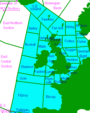
Shipping Forecast Areas

Map of the UK showing the Shipping Forecast areas used by the Met Office during the Shipping Weather Forecast.
Viking, North Utsire, South Utsire, Forties, Cromarty, Forth, Tyne, Dogger, Fisher, German Bight, Humber, Thames, Dover, Wight, Portland, Plymouth, Biscay, Trafalgar, FitzRoy, Sole, Lundy, Fastnet, Irish Sea, Shannon, Rockall, Malin, Hebrides, Bailey, Fair Isle, Faeroes and Southeast Iceland
These areas are outside of the standard UK forecast
Denmark South, West Northern Section, East Northern Section, East Central Section, East Southern Section
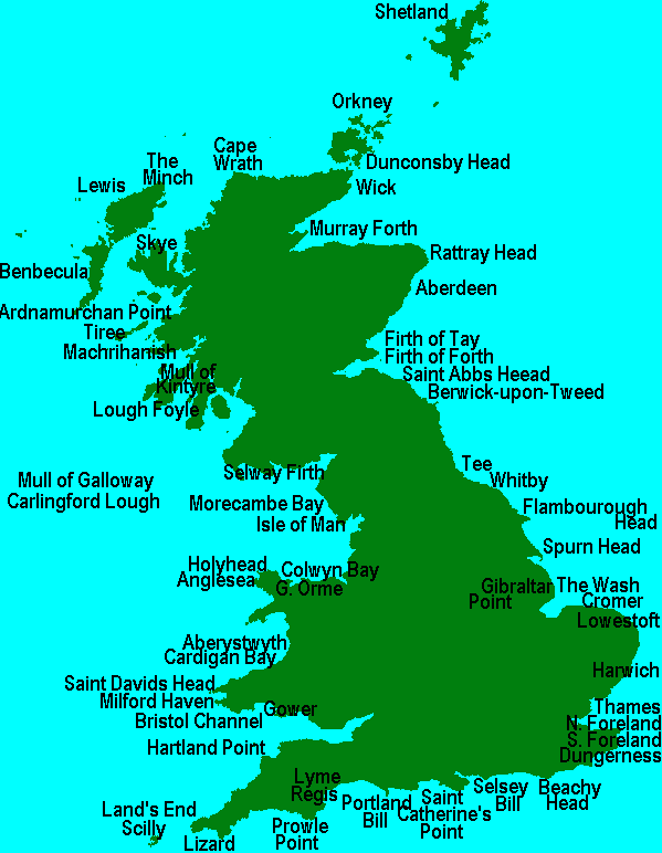
Inshore Waters Forecast

Map of the UK showing the locations referenced during the Inshore Waters Shipping Forecast provided by the Met Office.
Cape Wrath to Rattray Head including Orkney, Rattray Head to Berwick on Tweed, Berwick on Tweed to Whitby, Whitby to Gibraltar Point, Gibraltar Point to North Foreland, North Foreland to Selsey Bill, Selsey Bill to Lyme Regis, Lyme Regis to Land's End including Isles of Scilly, Land's End to Saint David's Head including Bristol Channel, Saint David's Head to Great Orme's Head including Saint George's Channel, Great Orme's Head to Mull of Galloway, Isle of Man, Lough Foyle to Carlingford Lough, Mull of Galloway to Mull of Kintyre including Firth of Clyde and North Channel, Mull of Kintyre to Ardnamurchan Point, Ardnamurchan Point to Cape Wrath including the Outer Hebrides, Shetland Isles
DigitalDan.co.uk
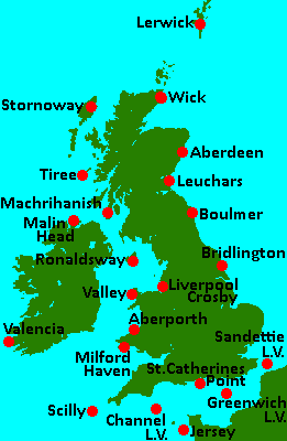
Coastal Weather Stations

Map of the UK showing the location of Coastal Weather Stations referenced during the Shipping Forecast.
Tiree, Stornoway, Lerwick, Wick, Aberdeen, Leuchars, Boulmer, Bridlington, Sandettie Light Vessel, Greenwich Light Vessel, Saint Catherine's Point, Jersey, Channel Light Vessel, Scilly, Milford Haven, Aberporth, Valley, Liverpool Crosby, Valentia, Ronaldsway, Malin Head, Machrihanish Automatic
DigitalDan.co.uk