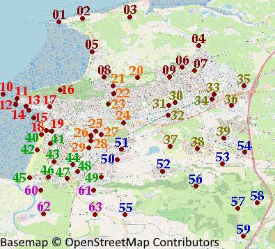
Key to Districts
01 - Sand Point
02 - Middle Hope
03 - Woodspring Priory
04 - Ebdon
05 - Sand Bay
06 - North Worle
07 - Castle Batch
08 - Kewstoke
09 - Lynch Farm
10 - Birnbeck Island
11 - Birnbeck
12 - Anchor Head
13 - Marine Lake
14 - Knightstone
15 - Grand Pier
16 - Weston Woods
17 - Grove Park
18 - Beach Lawns
19 - Ellenborough Park
20 - Golf
21 - Worlebury
22 - Milton
23 - Ashcombe Park
24 - Hutton Moor
25 - Winterstoke
26 - Weston Retail Patk
27 - Searle Crescent
28 - Gallegher Retail Park
29 - Bourneville
30 - Bird Land
31 - Mead Vale
32 - Weston Village
33 - Worle Parkway
34 - Locking Castle
35 - Saint Georges
36 - West Wick
37 - Oak Tree Park
38 - Locking Village
39 - Locking Parklands
40 - Tropicana
41 - Clarence Park
42 - Royal Sands
43 - Broadoak
44 - Windwhistle
45 - Folly Lane
46 - Uphill
47 - Weston General Hospital
48 - Coronation
49 - Oldmixon
50 - Europark
51 - Hauwood
52 - Hutton
53 - Elborough
54 - Locking Grove
55 - Bleadon
56 - Canada Combe
57 - Hamwood
58 - Christon
59 - Loxton
60 - Walborough
61 - Bleadon Hill
62 - Bleadon Levels
63 - Purn Park
 Weston-super-Mare Districts